
A Trip in the Far North
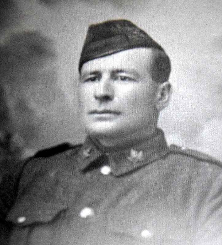
William Murray Gibson, my first cousin twice removed, was a lad of 18 when he travelled on a freighter from Edmonton to Hay River on Great Slave Lake and back again.
He was born on the Scotch Line, not far from my childhood home near Perth, Ontario, and received his early education at the Allan’s Mills school. His mother Janet Miller, my great aunt, was a sister of my great grandfather Robert Miller.
He homesteaded on 15-40-27-W4 near Lacombe, receiving his homestead grant in 1898, just before leaving for his voyage north that year. Homesteading requirements were fulfilled shortly after and a patent was issued. His family moved from Bathurst township, Lanark County, Ontario in 1900, taking up land nearby.
Murray died as Acting Corporal for the 10th Battalion on 11 Nov 1917. He was killed in action while with his Battalion in the attack on Passchendaele Ridge. He was hit by enemy shell fire, death being instantaneous.
The following letter was sent to his father, arriving just before Christmas 1898.
A Trip to the Far North – published 20 Jan 1899
Perth Courier, Perth, Lanark County, Ontario
Mr. A Murray Gibson, son of Mr. W.M. Gibson, Scotch Line, has written an interesting letter to his parents of a trip he made up and down the raging Athabasca River, and we have been allowed to publish extracts from it. This northern country has been much travelled over and written about lately, and this letter gives Courier readers some idea of its topography.

Edmonton, Northwest Territories Oct. 30, 1898
Dear Father:
I must tell you something of my trip north this summer in as short a space as possible. It would take a week to write it all down.
From Edmonton north to Athabaska Landing [on the Athabaska River] is over 100 miles of sand hills and sloughs – no good land. We went over this by freight-wagons. The landing is quite a busy place. The Hudson’s Bay Co. have quite large warehouses here, as have several Edmonton companies. All the goods and travel from the north start from here. We had five ten-ton scows. They were 35′ long and 15′ or so wide. We started on the second of June. There is nothing much of interest but a few gas wells till the head of the Grand Rapids is reached. This is the head of 86 miles of solid rapids, the first 1 1/2 miles of which is the worst. All the goods have to be unloaded, packed and taken overland one mile, then the boats run and loaded again. There were lots of Klondikers here; they kept us in fun, though it was hardly right to laugh at the poor fellows. At one time, some of them were letting down a boat when their rope broke. There were two men in the boat; their eyes bulged out as the boat shot down the rapid. We were letting down a boat about 50 yards below and we shouted to them to steer their boat clear of us, but a man cannot be heard 20 feet away. They reached up and caught our line and the boat was jerked from under their feet in a second. Then they went hand over hand, sometimes under the boiling water and sometimes on top till they got to our boat. It gives one the idea of the grip a drowning man has. When the foot of this rapid is reached, the boats are loaded in a big eddy, then there is a short but dangerous rapid below. Some Englishmen thought they could run this without a guide. They started off bravely enough and got on all right till the rapids got bad; then they got into the wrong channel and one minute the boat was pointing to the clouds and the next into the ground. The men seemed paralyzed. They ran broadside on till it struck a rock and was lifted almost out of the water. They lost all of their outfit, and almost their lives. We got down all right, so did most of the H.B.Co.’s boats but one of the pilots in turning the boat slipped on a wet plank and the boat ran against a rock, cutting a hole in her. They ran for the shore and tried to hold her with ropes, but the current was too strong and swift and swept them down the rapids. Most of the cargo was lost and all Her Majesty’s mail for the North. Accidents like these were happening, almost every day. There are Mounted Police here. No whiskey passes this point and no one without a year’s supply of provisions. All the rest of the rapids can be run with a full cargo except the cascades, the first a drop of 6 feet and the next 4 feet.
Fort Mc Murray comes next – just a Hudson’s Bay Co.’s post and an Indian encampment. From here to Lake Athabaska, the river is very wide, with numerous islands. The banks are very high, often 600 feet, and are sometimes formed of a kind of tar asphalt. In hot weather this melts and can be used for calking boats. For 60 miles before reaching the lake, the banks are low and muddy. As far as can be seen on either side, it is just one big hay slough.
Chipewyan is twelve miles from the mouth of the river. It is a splendid looking place, and its great white forts can be seen for miles out on the lake. Seen from the fort, the lake stretches away to the east till it meets the sky. This lake is about the size of Lake Ontario.
There are several traders at the fort, and there are a few other buildings including a fine Roman Catholic church. It is 14 miles to the mouth of the Slave River, and 30 miles further, the Peace comes in, making the Slave no small stream. It is full of beautiful islands, and has high, heavily timbered banks. The country all around is covered with heavy spruce; it is sometimes dark under the trees; they are so thick. Black bears, cinnamon bears, moose, etc. all very numerous.
Smith’s Landing comes next. It is at the head of the Smith Rapids. These rapids are only 16 miles long, but they are sixteen times worse than anything we had seen yet. Four times the boats had to be taken out of the water and dragged a short distance and put in again. Between times, we would run rapids that would make one’s hair stand on end. The H.B. Co. built a wagon road around these rapids many years ago and take their goods around on ox-carts. The river is very wide and is just one sheet of foaming cascades. Looking at it from a distance it reminds one of a stampede on a sheep ranch. Fort Smith is just like other posts, – the usual H.B. Co.’s post, R.C. Catholic Church, traders, freighters, and Indian tepees.
There is nothing of much interest to be seen until we reach Fort Resolution, unless Salt River where pure white salt can be shovelled up by the carload. We got to Fort Resolution on the 6th of July, one month and eleven days from Edmonton. We reached Resolution at 5 o’clock in the evening and had to unload that night. Every Indian turned out to help, for which they were to receive their supper. Our cook was an ex-Mounted Policeman, and he said he would stand on the end of the cook boat and deal out every Indian his portion. He just did that for about three minutes. Those nobel red men and boys cleaned out that cook boat for themselves before the cook knew where he was. Some of them ate as much as five white men or more. Fort Resolution is something like Chippewayan. They have a splendid R.C. Church, the brothers in the church built it themselves. The church is as fine looking as the one at Dewitt’s Corners. Every board in it was whip-sawed, dressed, tongued and grooved by hand. The shingles and the mouldings and ornaments are all hand made, even the paint is made here. It is painted a brilliant blue with gilt trimmings to catch the Indians’ eye. The spire can be seen 23 miles out on the lake. There are only one or two seats in it, the Indians squat on the floor and make responses in Latin. We had only been there a few days when five of us were sent across the lake to St. Peter’s Mission to get Mrs. Nagle (our foreman’s wife) and her two children. One of them was only three months old. We had a fine sail of 75 or 80 miles. This is an English Church mission; there are two men and four women managing it. We stayed there two days and I assure you these people made us feel at home. One of the lady teachers is 6 ft.2 in. in height. She is the only white woman who ever saw Hay River Falls. They are situated on the Hay River which comes in here and have a clear drop of some 60 feet. Coming back we camped two days at Sulphur Point, on account of a heavy storm. On this point is a sulphur spring almost 16 feet across. The water is too strong to drink. There is not a vestige of any green thing growing around this spring. This made a fine camping ground on account of the fine little harbour and the entire absence of mosquitoes. Another time we had to run up Buffalo River to get out of a sudden squall. This is the river on which the big silver mine has lately been found. You will have seen about it in the papers. On an island, we saw marked “Wm. Ogilvie No. 10”. The great Yukon man has evidently been here sometime. We got back to the fort seven days from the time we left, having got about two tons of furs at Resolution. Most of it was rough fur, – musk ox, bear, and wolf hides. There was one big grey timber-wolf skin that would nearly cover your kitchen floor.
About the first of August, we started on our 1,000-mile trip to Edmonton. A great part of the distance was made in this way: a long line was run from the boat to the shore; we then fixed on our pack straps about six feet apart, put them over one shoulder and under the other arm and away we went over mud, bush, rocks and along the edge of mountains where there was only a nick here and there and the least carelessness would send a fellow plump into the river 30 or 40 feet below. We sailed a good deal of the way and reached Fort Smith in six days, making the fastest trip on record. In the Grand Rapids, we had the hardest work; it took us ten days to come up them. We often got fresh fish and berries from the Indians. We had few mishaps or accidents. When we came in sight of Athabaska Landing, as soon as the warehouse and tepees hove in sight, the boys just cheered and yelled like wild Indians. On the 12th September, we were back to Edmonton. In a few days the boys scattered in every direction – British Columbia, California, Texas, Manitoba, Assiniboia, and to places in Alberta.
W. Murray Gibson
attachments:
“Down North Map”
This story was incorrectly named on Ancestry by grantg5 (10 Feb 2014) who shared a version of this – 1898 Expedition “Down North”, indicating that the original source was a handwritten extract by a reporter for the “Courier”.